|
Updated: @
16-Apr-2026 12:30pm - next update at 12:35pm
|
| Summary / Temperature |
Wind |
Rain |
Cloud Level |

|
Few Clouds
|

|
70.9°F

Comfortable
Feels like:
71°F
24-hr difference
-7.7°F |
| |
Today |
Yesterday |
| High: |
71.7°F
2:21am
|
81.4°F
3:47pm |
| Low: |
62°F
8:33am
|
65.4°F
7:58pm |
|

|


|
SW
11
Gust:
22 mph
|
|
3 Bft -
Gentle breeze
|
|
Today:
24 mph
4:05am
|
|
Gust Month: 56 mph
April 2
|
|
| Rain Today: |
0.01 in
|
| Rain Rate (/hr): |
0 in
|
| Rain Yesterday: |
0.64 in
|
| This Month: |
1.5 in
|
| Season Total: |
13.14 in
|
|
0 day since last rain. |
|
|
| Humidity & Barometer |
Almanac |
Sun/Moon |
| Humidity: |
68 %
|
| Dew Point: |
59.8°F
|
| Barometer: |
29.92 inHg
|
| Baro Trend: |
Rising
|
|
| Sunrise: |
7:07am |
| Sunset: |
8:25pm |
| Moonrise: |
6:24am |
| Moonset: |
7:52pm |
|
Sunlight:
Today:13 h 17 m 34 s
(Noon)

(Midnight)
|
|
Waning Crescent |

|
1%
Illuminated |
|
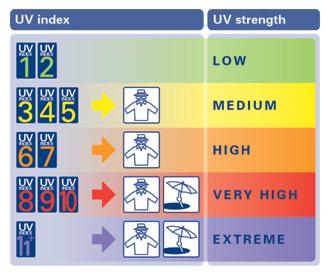
| UV Index Forecast |
Severe Weather Outlook |
|
|
16-Apr-2026 |
|
6.9
High |
|

|